Finding North Korea's Missile Launchers
MIDDLEBURY, Vt. – An analyst from the Monterey Institute of International Studies captivated an audience of about 75 Middlebury students and faculty on Feb. 20 showing how she used 3-D modeling, satellite imagery and social media to discover secrets about North Korea’s nuclear missile program.
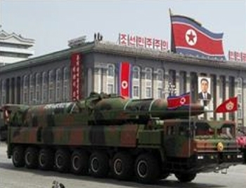
Melissa Hanham showed how a simple photograph taken in 2012 at a North Korean military parade (and later posted on the Internet) sparked months of research that led her team to draw conclusions about a new type of intercontinental missile North Korea has in its possession. Hanham also determined how North Korea transports and launches the missile, what its capabilities are, and – most remarkable of all – two clandestine locations where mobile missile launchers are housed.
Hanham is a research associate at the James Martin Center for Nonproliferation Studies, a division of Middlebury’s graduate school in Monterey, Calif. She was invited to Middlebury by Tamar Mayer, professor of geography and director of the Rohatyn Center for Global Affairs, who set the stage for the presentation saying that North Korea is an “enigma… a country shrouded in secrecy and a country about which we know very little.”

=”0” alt=”parade” title=”parade” width=”350” height=”268” />

“0” alt=”ws51200” title=”ws51200” width=”350” height=”208” />
Professor Mayer said it is especially important to learn more about North Korea because of its proximity to South Korea, China and Japan, and because of the region’s importance to the global economy.
North Korea “has threatened to carry out preemptive nuclear strikes against the United States, but do we know what their arsenal entails? Do we know if they really have such capabilities? Do we know if these threats are real?” the geographer asked. Before turning the podium over to Hanham, Mayer said North Korea has an operational plutonium reactor, it has expanded the size of its uranium-enrichment facilities, and it conducted a successful nuclear test in February 2013.
The guest speaker showed the parade photograph of a missile mounted on the bed of a 16-wheel flatbed truck, and explained that it was posted on the Internet after an April 2012 event in Pyongyang at which six road-mobile missiles were displayed in North Korea.
Hanham said the East Asian nonproliferation analysts in Monterey were surprised to see the photo, and wondered what kind of missile it was, what type of launcher it employed, how it was transported and what its range, size, engine and fuel source might be.
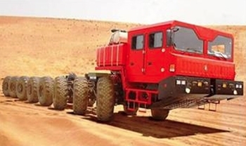
Using the parade photo, a picture from a Chinese marketing brochure and 14 seconds of footage on YouTube showing Kim Jong Il touring a facility where missiles are housed, Hanham’s group determined:
– the style of missile – a KN-08 intercontinental ballistic missile capable of delivering a nuclear warhead,
– the origin of the trucks used to transport them – six WS51200 trucks that were purchased from China and shipped to North Korea for “forestry” purposes, and
– the kind of launcher – a transporter erector launcher, or “TEL,” similar to a style manufactured in Minsk, Russia, and mounted on the bed of the trucks.
A brief video clip contained within a propaganda
called “Kim Jong Il’s Efforts to Defend the Country,” shows the only known footage shot inside a North Korean facility for assembling and housing TELs for ballistic missiles, Hanham said.
The footage provided Hanham’s team with sufficient information about the size and shape of the facility, the number and configuration of the building’s windows, and the design of the roof and cupola that the experts were able to create 3-D models of the building using SketchUp software and other tools. The renderings revealed something else the team at MIIS had not expected: the video was actually shot in two different structures, one containing the KN-08 missiles and the another containing older, but just as potentially deadly, Nodong-1 missiles.
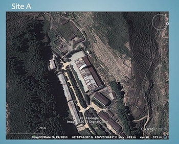
Hanham’s next task was to find the location of the structures. Using accounts provided by North Korean defectors and crowdsourcing websites, the team from Monterey narrowed down the search area. It employed Google Earth and satellite images acquired from Astrium to ultimately locate and identify two specific sites where it believes North Korea’s mobile missile launchers have been assembled and housed. Both locations and the methodology Hanham used are detailed in an article on the website 38 North.

” alt=”sitea-350” title=”sitea-350” width=”350” height=”282” />
During the question-and-answer session that followed, a Middlebury undergraduate asked Hanham: “What was the purpose of all this work?” She replied that the nonproliferation team had two objectives:
“One, we genuinely wanted to find these buildings because knowing their locations can help us prevent future technologies like this from [going undetected.] We have been following this case ever since the Chinese trucks showed up in North Korea because China has very good export control laws, but it has a hard time enforcing them.”
“The second reason we researched this topic was to prove the point that you can use these tools” – the Internet, social media, 3-D modeling, Google Earth and satellite imagery – “as a methodology to answer questions like this.”
Hanham, who holds a master’s degree from Columbia University’s School of International and Public Affairs, and worked for the International Crisis Group in China and South Korea, said there are other pressing applications for the type of mapping she did in North Korea.
“You could use these same tools if you were trying to locate environmental damage or human rights abuses or the victims of chemical weapons strikes” in almost any region of the world.
Written by Robert Keren


