

A new era of earth science with LiDAR
–
McCardell Bicentennial Hall 417276 Bicentennial Way
Middlebury, VT 05753 View in Campus Map
Free
Open to the Public
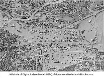
Airborne LiDAR (Light Detection and Ranging) is a technique that measures surface elevation using an aircraft-mounted laser. The result is an extremely detailed rendering of Earth’s surface, with a typical resolution of about 1 m. As Vermont moves quickly towards statewide coverage, LiDAr is enabling countless new applications in fields such as hydrology, soils and agriculture, ecology, forestry, and land use management. Reed Sims (USDA/NRCS), a key advocate for LiDAR coverage in Vermont, will speak about how LiDAR data is being used to study problems such as nutrient pollution and flood mitigation.
Join us to learn how this novel technology will enable new approaches to addressing these and other environmental issues in the coming decades.
- Sponsored by:
- Earth and Climate Sciences
Contact Organizer
Amidon, William H.
wamidon@middlebury.edu
443-5988