Geology Professor Explores Shipwrecks of Seneca Lake

The College’s research vessel the David Folger is usually on Lake Champlain and serves as a floating classroom, where Tom Manley, assistant professor of geology, or other faculty and students hold class or do research. In the Q&A below, Manley discusses why he journeyed on the Folger to Seneca Lake, one of New York’s Finger Lakes, and what contributions the Folger is making to the region. By surveying the lake, Manley is helping to accomplish two goals: the creation of an inventory of submerged cultural resources and the systematic mapping of the underwater topography of Seneca Lake.
What brought you and the Folger to Seneca Lake, one of New York’s Finger Lakes? How many times have you been there and when?
The concept of this program began in the summer of 2018 when Art Cohn, cofounder of the Lake Champlain Maritime Museum, asked if I would be part of a preliminary side-scan sonar survey to locate the Frank Bowley, a canal boat that sank in Seneca Lake in the late 1800s. While he was doing research for a book, he found a newspaper article that described where the canal boat had gone down. If it could be found and documented, it would represent the first tangible connection to what we predicted would be a collection of actual ships that were critical in the overall settlement and development of the region.
Who else joined you on your trip?
I invited Angus Warren ’20, a student in one of my courses who had also worked on a summer research program with me on Lake Champlain, to participate in the search for the Frank Bowley, due to his intense interest in history and nautical archaeology. Tim Caza and Dennis Gerber joined us as the primary survey team. Tim owns and captains the 24-foot research vessel that we used for surveying while at the same time is the primary scuba diver for investigating the shipwrecks. Dennis is a retired electronics engineer who designed and built the side-scan sonar system that they use for locating shipwrecks.

What did you find there?
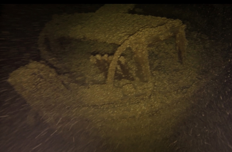
The day we started the survey was one of those warm, picturesque days with blue skies and a light breeze. We traveled south to the reported site where the Frank Bowley had sunk and began our survey. Within two hours, we had located the shipwreck, which hadn’t been seen since 1869. Our preliminary imaging of the target from our different viewing angles revealed a shipwreck in untouched and pristine condition. It didn’t take us more than a few minutes to agree on the continuation of the survey. By the time we left for home some two days later, an additional seven shipwrecks had been added to the list of discoveries.
What is the significance of your findings?
The discovery of the Frank Bowley, and the locating of seven additional shipwrecks, gave credibility to our belief that Seneca Lake, and other Finger Lakes connected to the New York State (NYS) canal system, would contain a significant collection of canal-era vessels. In today’s legal framework, all nonmilitary shipwrecks more than 50 years old are considered public cultural resources to be managed by the states in whose waters they lie. We were working under an NYS Museum Archaeological Permit, and the shipwrecks located in the survey, together with our preliminary observations, identification, and information about their ages, origins, and conditions, will become a part of the NYS inventory.
Are you mapping the bottom of Seneca Lake?
Yes. The survey has two primary objectives: to create an inventory of submerged cultural resources and to systematically map the underwater topography of Seneca Lake. This was a process we had developed and perfected during our decade-long Whole Lake Survey on Lake Champlain, and the RV David Folger is the perfect platform for accomplishing this valuable and ambitious goal.
What will this map be used for?
This will be a bathymetric map, which measures the water depth across a body of water. The standard bathymetric chart that is presently used on Seneca Lake and distributed by the National Oceanographic and Atmospheric Administration (NOAA) is based on information gathered in the mid- to late 1800s. Fishermen, boaters, sailors, scuba divers, scientists, the U.S. Coast Guard, and, believe it or not, the Navy, which operates a sonar testing platform in the middle of the lake, use this outdated chart as the most definitive representation of bottom bathymetry.
The new data we provide is going to significantly alter the knowledge base of this lake. This publicly available data set will eventually lead to a newer generation of bathymetric charts that will benefit a wide spectrum of state, public, and research programs.
In the process, we will also create an inventory of the submerged cultural resources that will permit the state of New York to better preserve, study, and manage this extensive collection of shipwrecks reflecting on the historic use of the Seneca Lake as a commercial waterway.
Are you returning there? Will any students join you?
Provided funding is available, we expect to return during the summers of 2020, when we would complete the mapping of the central portion of the lake, and 2021, when we would complete the rest. We anticipate working with New York State officials, scientists from Hobart & William Smith College, and many other partners to maximize the use and value of the data.
For both the summers of 2020 and 2021, I expect to have two Middlebury students on the RV Folger to help with the Seneca Lake survey.

